


Monday 7 August 2019
| Distance (km) | 18 kms | |||
| Distance (time) | 8.5 hrs | |||
| Climb / Descent | 8700m / 1070m | |||
| Hard / Soft surface | 20% / 80% | |||
| Landscape |
|
|||
| Weather |
|
|||
|
|
||||
|
From Col de Bassachaux to Samoëns is too far for us to walk in one day, but since there are for sure 5 places to stay overnight it shouldn't be too hard to split it in two. You would say. But it nevertheless took some effort to get it arranged. Our first choice for a nice split in two equal days would have been Refuge Chardonnière, but it was fully booked. Then Chalet des Mines d'Or, though a bit further from the GR5, but it was fully booked as well. Option number 3 was Le Lapisa but they simply didn't answer the phone....so we were with 2 options left: Refuge de Chésery which is only an hour or so from Rochassons and thus too close, or Refuge de la Golèse that is only 2-2.5 hours before Samoëns and actually a bit far. But still better, so let's give it a try. And yes....almost to my surprise they had still space and we could even get us a room instead of just a bunkbed in a dormitory. So yes please.
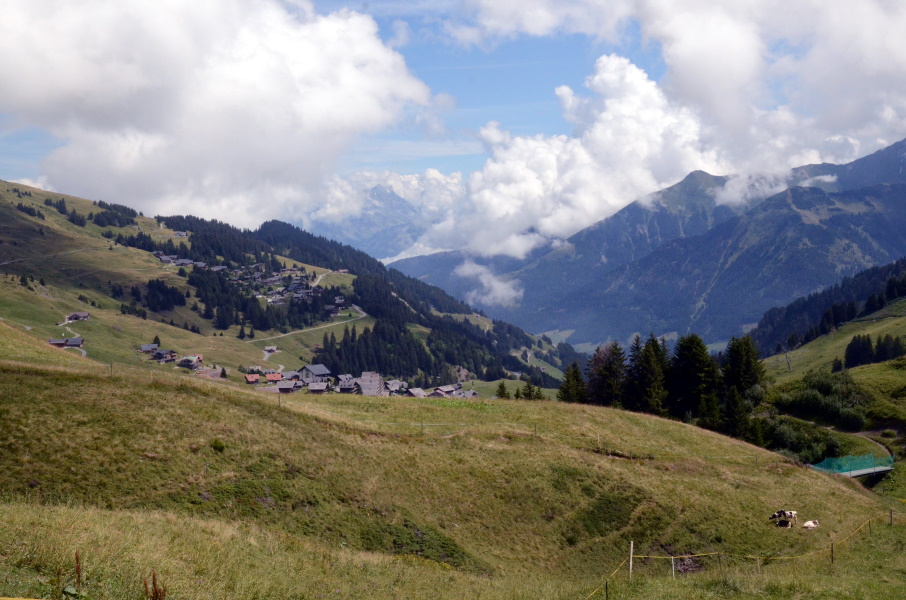
It will be a long walk for sure and since the first ski lift up to Rochassons doesn't go until 9:30 it's not the early start we would have preferred. But ok, we take the shuttle to Pré la Joux and the 2 ski lifts up to Rochassons where we descend to the GR5. It is pretty flat here and easy walking towards Col de Chésery where we will cross the border into Switzerland. After the pass it hardly drops to Lac Vert (Green Lake) where we pass the first mountain hut: Refuge de Chésery. We also have our first break here to eat something. From here we have to climb to Col de Portes de l'Hiver on the other end of the lake and one can walk on either side of the lake. Officially we should go along teh south side, which is a track. Unfortunately there are a lot of people on that track including several groups. The alternative is the gravel service road along the north side of the lake, which is actually meant for mount bikes. But there are hardly any mountain bikes and looking at the track again we decide to use the service road. It is not a hard climb and soon we're at 2096 metres, the highest point we've reached on the GR5 so far. The gravel road continues into the valley on the other side and so do we, but soon after the summit we have to turn right onto a rural track. There are quite a few mountain bikers on this track but they announce themselves quite well and there is enough space to not making it an issue. We have to go down all the way to Chaupalin that happens to be a restaurant we were not aware of. Here we have to chase away some cows first before we can climb the fence and find ourselves on a little tarmac road. We meet with a young Swiss couple that is walking in the opposite direction and we have a short talk before spliiting agan. This is the beginning of a very relaxed part along a tiny tarmac road until Le Lapisa. The view to the left with the valley of Champéry and the high Dents du Midi with glacier on the other side is pricells. We pass Le Lapisa (still don't know why they didn't answer the phone, but I am not in the mood to ask now) and leave the tarmac. On a narrow trail we descend over 100m before we again arrive at the tarmac road; the road just makes a large loop that we just shortcutted. We can also see straight ahead Col de Coux that we have to pass and it looks way to high from here. We pass the farmhouse La Poya and were the tarmac road turns left to descend into the valley we keep going straight ahead onto a track. We decide to take it slow as we see the mountains side towering above us and the little house at the pass. In the end it is not such a bad climb; very regular and it remains a wide track in rather good condition. So we reach Col de Coux smoother than we thought. Not much space to sit on this narrow V-gap, so we decide to go straight down again. Ah, and passing Col de Coux also means we're back in France. The descend is like the climb: a rather wide track without any difficulties. Just going down. We pass the side road to Chalet des Mines d'Or and with a couple of switch backs we arrive at a fierce little streadm: Torrent de Chardonnière. It comes flushing down the mountain, but looking at the blocks of rocks here it has rougher days than today. We cross that also implies we're no longer on the gravel road but now on a narrow track again. At the lowest point the track forks and to the right it's a 5 minutes walk to the Refuge de Chardonniè that unfortunately is also full. The track gently climbs along a grassy slope before going into the woods again. We're on our last energy and so climbing is very slow but at least the gradients are very reasonable. This changes when we reach the gravel forest track. Turning left here the track is quite steep and irregular. We also leave the forest again and so we're walking in the sun. We can see where Col de la Golése is and it looks so close but takes so much time. But finally after the last turn left we can see the track flattening. The refuge is hidden around the corner on the left and we're so happy to reach it. Our reservation still stands, but there is a catch: the shower broke down. Hence, we have to queue almost an hour for using the sink to be able to spunge ourselves clean, more or less. It is kind of bummer, but after that dinner makes up for it. |
     |
|||
|
|
||||
Download track BasGol.gpx