


Wednesday 8 August 2018
| Distance (km) | 29 kms | |||
| Distance (time) | 9.5 hrs | |||
| Climb / Descent | 830m / 780m | |||
| Hard / Soft surface | 25% / 75% | |||
| Landscape |
|
|||
| Weather |
|
|||
|
|
||||
|
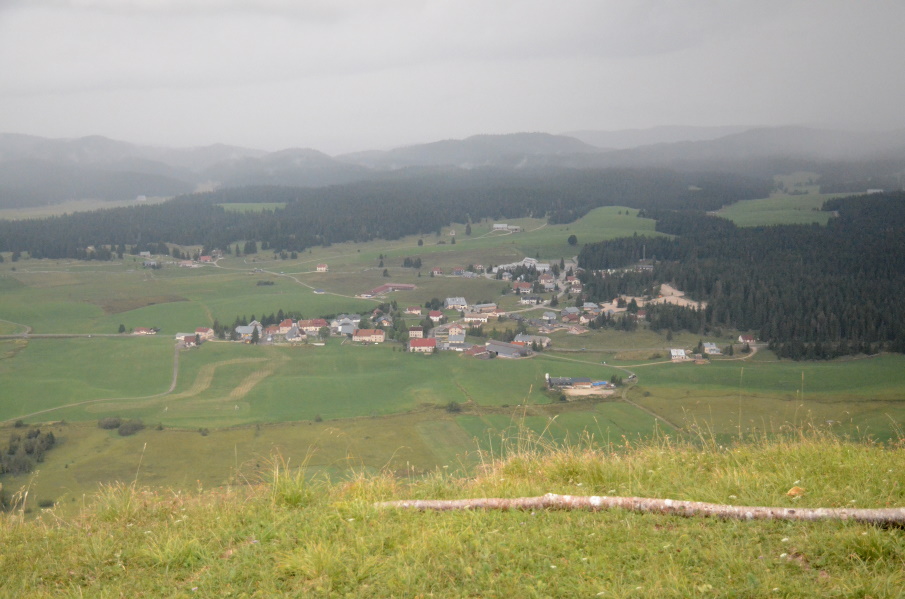
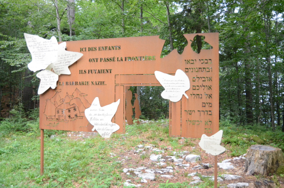
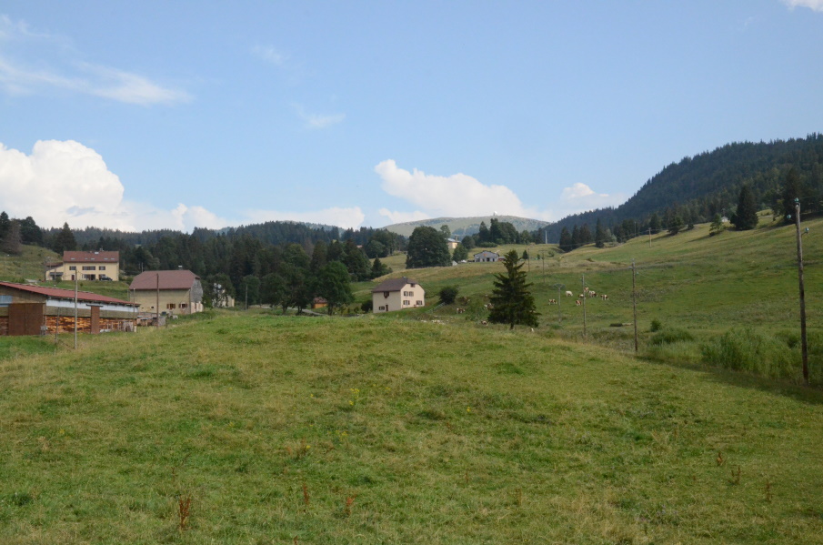
Since today will be a long day we asked once more for breakfast at 7am and we're told that is no problem at all. But in the morning at 7....there is not much going on. The owners of the hotel overslept and are now running around to get breakfast arranged. And they're quite efficient, because we do manage to start walking just after 8am in the end. The sky is grey with very little room for the sun peeping through and it looks like the forecasted thunderstorms might come earlier than expected. The good part is of course that it is cooler now and we have to start with a climb almost immediately out of the village. For a short while it is just a tarmac road going up (though not so gentle) until we have to turn left and enter cow territory again. We walk fast by silently to not draw the attention of the cows and by the time we reach the woods we are sweating, in spite of the sun being concealed by the clouds. We are suddenly surprised by a big thunder and I recall mentioning something about early thunder today. But I didn't have 8:30 in the morning in mind when I mentioned "early". The real climb is still to start and it is a serious climb over a narrow goat trail zigzagging up the mountain side. The thunder is getting louder and we try to climb as fast as we can to take advantage of the still dry trail. Some serious rain would probably make the trail quite slippery! We reach the high point when a few drops fall and looking down from the viewpoint (with a magnificient view, by the way) to Chapelle we see a rain shower passing over the village while we are literally high and dry. Once up here the path undulates and rolls more or less following the edage of the cliff. We also follow the French-Swiss border here and we see some ancient border stones on our left. The thunder shower left as fast as it came and the sun tries to gain terrain. The path just keeps going up and down and twisting through the forest. We pass an interesting monument in rememberance of all the people that guided French jewish children to safety in Switzerland during the second world war and we stop for a moment. With this level of difficulty it is going to be a long day today and by the time we reach the Chemin du Grand Remblai (a forest road) we need a break. We can again hear thunder in the distance but it's not raining so we sit down on a log. After a short break with a muesli bar we continue and to our relieve the forest road is considerably flatter than the path we followed so far. We arrive at the next forest road (Chemin Neuf) and this well maintained gravel road is first slightly descending before flattening to a crossing in the forest: Plan des Buchaillers. We keep having thunder in the background but it doesn't seem to get much closer. From here on we follow a real tarmac road for a while, and we even encounter a few cars. Later it's back to gravel tracks again to another crossing in the forest (Plan Pichon) and finally to a little emergency hut, Chalet Rose. Time for another break since we have walked 2 hours again. It is clearly easier now, because in the first 2 hours we walked 4 kms and in the seond 2 hours we walked 8 kms. Leaving Chalet Rose we once more hear thunder in the distance but we're getting used to it and decide just to push on to Les Rousses. It is again not too difficult through the forest. We catch up with a Swiss walker that has a way too big back pack. He tries to keep pace with us but since we only carry our close and some toilettery it's not really a match and we leave him behind again. The descent into Les Rousses is irregular but not so difficult and sow we enter the residential area of Les Rousses-en-bas. And it is called "en bas" for a reason....to get to the town centre we still have to make a nasty little climb. And we almost make it....dry I mean. Entering the village centre it suddenly starts raining and again with thunder. Where does that all come from today? We sit underneath the sun screen of a clothing store waiting for the rain to stop. An old lady accompanied with a middle aged woman enter the store and make a remark about us sitting there. So I explain that we're waiting for the rain to stop before walking on to La Cure. The ladies disappear in the store and a few minutes later the younger one of the ladies come out of the store again asking whether we need a ride to La Cure. She's going there anyway by car and if we prefer a ride instead of walking? Very sweet, but we thank her for the offer and say we'd rather walk. In fact, we take advantage of our compulsory break by getting some cakes from the bakery and 2 cans of coke from the souvenir store and make this our mid-afternoon-snack-break. But finally the rain eases and we decide to start walking again. We pass the old fortress of Les Rousses and we are back in the forest. The path keeps descending, which sounds nice but knowing that La Cure is at higher altitude then Les Rousses it is also a bit worrying. But finally we reached the lowest point from where we apparently have to walk in the direction of a gite called La Grenotte. We follow a tarmac road and go back in the fields, climbing easily to La Grenotte. By then we think this is all not that bad, but in fact the access road from La Grenotte to the D29 main road is bloody steep going up. So we're happy to reach the main road from where it is just another 1.5 kms to La Cure. The tarmac is not pleasant on our feet and the road is not completely flat either. Closer to La Cure we climb through an area with rather big houses to reach the big roundabout at the entrance of the village where the D29 and N5 main road meet. It's just a few 100 meters from here and finally at almost 6pm we reach the car.... Now we only have to go to the supermarket (in Les Rousses - how disappointing to drive there in 2 minutes) and pitch our tent in St. Cergue. One more day to Lake Geneva... |
   |
|||
|
|
||||